
Local Cemeteries | Kitsap County
Home > Local Cemeteries > Kitsap CountyThis is a listing of sixteen cemeteries in the Gig Harbor Peninsula Area. Parcel numbers are from the Pierce, Mason and Kitsap County Assessor’s websites. Other information is from a site check of posted signs and GPS coordinates done by Frank Bannon of Artondale Cemetery Assn.
Fox Island
Fox Island Cemetery
The Fox Island Cemetery is located in the 600 block of Island Blvd, Fox Island, WA.
Lat: 47° 15.995’ and Lon: -122° 38.210’
On 6th Ave FI, just beyond Hyak Dr FI, near the curve, on the left (east side).
Parcel No. 0120021003, 2.00 Acres, T20N R1E SEC2
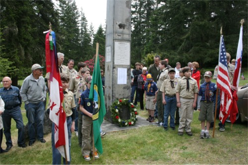
Many war veterans are buried there, as well as Fox Island's early pioneers, and Washington's Governor Dixy Lee Ray.
Each year the Boy Scouts and Cub Scouts of Fox Island gather to honor Fox Island's veterans by performing a flag ceremony on Memorial Day.
A reading of the names of Fox Island's veterans, dating back to the civil war, follows the raising of the flag.
For more information, Please contact:
Fox Island Cemetery Association
Contact:
Judy Wilson
253-686-0274
Cemetery Address:
797 6th Ave FI, Fox Island, WA 98333
Mailing Address:
PO Box 9,
Fox Isla... Read More
Gig Harbor Area
Weeks' Haven of Rest Funeral Home Crematory and Cemetery
Lat: 47° 20.069’ and Lon: -122° 36.106’
8503 Hwy 16, On Hwy 16 just west of Rosedale Street NW, Gig Harbor, WA
Accessible from west-bound Hwy 16 only.
11 Parcels total. Nos. 4000130010-4000130070, 4000140010, 4000150010, 4000170010, and 0221063032, 5.55 Acres total, T21N R2E SEC
Rosedale Cemetery, Established 1896
(AKA Greenwood Cemetery)
Lat: 47° 19.776’ and Lon: -122° 38.653’
On the east side of Rosedale Street NW, just beyond 78th Ave NW, Gig Harbor, WA
Parcel No. 0121112057, 3.82 Acres, T21N R1E SEC 11
Gig Harbor Cemetery, Established 28 Aug 1891
(AKA Old Gig Harbor Cemetery, Crescent Valley Cemetery)
Lat: 47° 21.105’ and Lon: -122° 34.297’
North Gig Harbor at the end of 22nd Ave NW.
Parcel No. 0222324001, 4.68 Acres, T22N R2E SEC 32
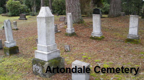
Artondale Cemetery, Established 1895
Lat: 47° 18.918’ and Lon: -122° 36.718’
Address is 5512 Hunt Street NW,
Gig Harbor, WA 98335
(Not a mailing address)
Parcel Number 0121131003, 2.75 Acres. T21N R1E Sec13
Mailing address: 7722 84th Avenue Ct NW, Gig Harbor, WA 98335-5209
Key Peninsula
Victor Cemetery
Pierce County at the Mason County line
(AKA Pederson Family Cemetery)
Lat: 47° 23.362’ and Lon: -122° 48.064’
Located 1.4 miles east of State Highway 302 on the Victor Road, on the NW corner of the intersection of 144th St KPN. It is located on the NW corner of the crossroads of a power line and dirt road, bordering the Mason/Pierce County Line, the cemetery being in Pierce County.
The site, approximately two acres, was donated for use as a cemetery by the P. G. Pederson family in 1910 or 1911. It is partially fenced, has some brush, and receives only occasional maintenance from local volunteers.
Parcel No. 0022153002, 2.00 Acres. T22 R00 Sec 15
Vaughn Bay Cemetery
Vaughn, Key Peninsula, AKA Bay View Cemetery
Lat: 47° 20.869’ and Lon: -122° 47.126’
On the west side of 186th Ave KP N, just off Bay View Road, KP N
Address is: xxx-186th Ave KPN
Parcel No. 0022344080, 2.74 Acres, T22N R1W SEC 34 and
Parcel No. 0022344038, 2.84 Acres, T22N R1W SEC 34
Old German Evangelical Lutheran Cemetery
Lakebay
Lat: 47° 14.112’ and Lon: -122° 46.106’
Tax ownership: German Evangelical Lutheran Church
23rd Street KP S, Lakebay, WA 98349
At the tee intersection of 158th Ave KP S and 24th St KP S, on the west side of the tee.
Parcel No. 0020121029, 7.19 Acres. T20 R00 Sec 12
Niemann Family Cemetery
Vaughn, Key Peninsula
A private family cemetery across the street from Vaughn Bay Cemetery
Lat: 47° 20.849’ and Lon: -122° 47.114’
On the east side of 186th Ave KP N, just off Bay View Road, KP N
Address is: xxx-186th Ave KPN
Parcel No. 0022344047, 0.12 Acres, T22 R1W SEC 34
Minter Cemetery
Lat: 47° 22.877’ and Lon: -122° 41.680’
On the SE corner of Creviston Dr NW and 118th Ave NW in Minter.
In the same general area as Home Cemetery and is in the same neglected and over-grown state. Records indicate that it was donated by a family named Moss.
Parcel No. 0122282006, 1.00 Acres. T22 R1W SEC 28
Longbranch Cemetery
Lat: 47° 12.918’ and Lon: -122° 45.582’
Location: On NW corner of the intersection of Key Peninsula Hwy S and 46th St KP S.
Owned by Longbranch Cemetery Association
Parcel No. 0020144065. 2.08 Acres. T20N R00W SEC 13
Lakebay Cemetery
Lakebay, WA
Lat: 47° 15.472’ and Lon: -122° 45.700’ about
Tax ownership: Lakebay Cemetery Association
Location is just east of Cornwall Road, before the sharp corner to the left, opposite the lake.
Address: 222 Cornwall Road KP S, Lakebay, WA 98349
Parcel No. 0020021008, 0.70 Acres. T20 R00 Sec 02
Home Cemetery
Lat: 47° 16.768’ and Lon: -122° 46.340’
Owned by Peninsula Social Club Cemetery
Parcel No. 2709300055, which is part of a larger parcel,owned by Peninsula Heritage Land Trust.
Of all the Peninsula cemeteries it seems that the Home and Minter cemeteries are the smallest, with only nine recorded burials in the Home Cemetery and four in the Minter.
From the sparse records available on this land it would seem that Joseph Hieman on November 16, 1920, conveyed it to the Home Grange #701 of Home, WA.
Records further show that on May 29, 1922, the home Grange #701 sold the land to the Peninsula Social Club for $1.00 for the purpose of it being used for a cemetery.
With no active association to look after it, it has long since fallen into disrepair. The road leading to it is grown up with brush and is no longer accessible by car.
Par... Read More
Burley Cemetery
Kitsap County
Lat: 47° 24.704’ and Lon: -122° 38.194’
Across the street from 14964 Willow Road SE, Burley, WA 98322
A small cemetery on a hillside, fenced with a low wooden gate at the road.
Parcel (Tax Acct #) 4865-008-009-0000 and 0307. 0.40 Acres. T22N R1E SEC 11
Burley Library Association Cemetery